AANO Committee Report
If you have any questions or comments regarding the accessibility of this publication, please contact us at accessible@parl.gc.ca.
PART III – COMMUNITY SITE VISITSThe Committee undertook a series of site visits to individual First Nation communities across the country, each operating under different land management regimes. Community leaders generously shared their experiences and perspectives in relation to reserve land management. What follows is a brief overview of these individual site visits. MASHTEUIATSH FIRST NATION, QUÉBEC
Notably, much of the Mashteuiatsh First Nation reserve land base is allocated to band members through pre-existing Certificates of Possession (CPs), with few communal (or band) land holdings. Representatives of the band council indicated that this situation has resulted in little land being available for community economic development purposes and that economic development planning has not been as coherent as they would have liked it to be. A corollary issue for the band is that most of the revenue from land rent goes to the CP holder and the band only receives a nominal amount to administer leases. Although the First Nation has sought to repurchase CPs, they have found the process challenging and financially prohibitive. While the community would like to develop its land code within two years, they told us that they feel strongly that lands subject to an eventual land code under the FNLM regime must be in sound environmental condition before they would enact such a code. However, community representatives pointed to various significant environmental concerns with the CP held lands on reserve (i.e., sceptic tanks built too close to the water). They indicated that AANDC advised them that it is not responsible for remediating CP lands. The First Nation estimates that it would cost them $100,000 to remediate land on one CP alone. MILLBROOK FIRST NATION, NOVA SCOTIA
Chief and council members indicated that they have been able to achieve a level of economic success within the Indian Act land management regime. Notwithstanding its restrictions, Millbrook representatives indicated that they have made extensive use of the by-law making authority of the Indian Act, and have developed zoning, land use plans, building standards and taxation by-laws. They added that while entrance into the FNLM regime was considered, Millbrook First Nation’s preference is to remain under the legal protections afforded by the Act. Central to the economic success of the Millbrook First Nation was designating land along the highway for commercial development purposes (current site of the Truro Power Centre) in the 1990s. MFN indicated that their reserve land designation was instrumental in helping them to develop economically. Millbrook representatives expressed concern that the federal ATR process continues to be a slow and inefficient process. By way of example, we were told that MFN has been waiting 19 years for a 12 acre parcel of land to be added to their reserve. It was suggested that if all the requirements of the ATR policy have been met by a First Nation, the process should be expedited. MEMBERTOU FIRST NATION, NOVA SCOTIA
Representatives of Membertou First Nation indicated that the FNLM regime should be open to all interested First Nations, but recognize that there are federal funding limitations on the number of First Nations that can enter the regime at any given time. They explained that, unlike other First Nations, Membertou was in a position to “self-fund” participation in the FNLM regime, but were told at the time that the regime was closed to new entrants. Representatives told us that they should have been able to enter the FNLM regime when they were ready. Representatives also indicated that while the FNLM regime is a better alternative to the Indian Act, it is not ideal as they still see it as delegated authority by the minister. Echoing the view of other communities, the FNLM regime was described as a continuum of land management models with self-government being the ultimate goal. Among the reasons cited for participating in the FNLM regime is the rapid economic growth experienced by Membertou in recent years and the view that Membertou First Nation has gone “as far as it could” under the Indian Act. Specifically, the ability to secure long-term financing under the Act was identified as a key challenge and a principal motivation for entering into the FNLM regime. Executive Director, Trevor Bernard, explained that the move to the FNLM regime would boost the community’s financial development, since it would allow them to borrow money using its land as collateral.[144] With respect to the ATR process, Membertou representatives highlighted the fact that economic development is tied to the expansion of the reserve land base. In Membertou’s case, there was money available to expedite the ATR process as a result of the Marshall decision. They also recently completed an additional ATR on the “MacAulay lands”; a process that took 12 years, with delays largely attributable to the interests of a private land owner. In the end, MFN hived off the portion of land with the third-party encumbrance in order to complete the ATR. MUSKEG LAKE CREE NATION, SASKATCHEWAN
MLCN stated that they view the FNLM regime as a valuable tool to support economic development and employment, describing the regime as a collaborative initiative with government, but one led by First Nations. Similar to other communities, MLCN representatives described the regime as an important step toward the ultimate goal of self-determination. When implementing their land code in 2005 they sought to ensure that it would support progression toward this overarching goal. Representatives of the MLCN emphasized the value of a phased approach to land management and the usefulness of preparing First Nations to build the capacity to develop their lands and to take on additional responsibilities. MLCN representatives further indicated that governance is also very important and that the First Nation has taken steps to separate politics from business. Members heard that the MLCN has done a lot of work on developing sound governance structures and becoming more transparent, in particular through its community development plan. Chief and council members indicated that CPs are a difficult issue in the community, but that under the FNLMA they now have a tool to regulate these lands and to enforce environmental codes. They explained CPs were issued to veterans by the federal government after the war, thereby reducing the communal land base. This is an ongoing issue for the community and a specific claim has been submitted in this regard. Representatives indicated that it is possible to develop on-reserve lands and that it is possible to “have our lands worth something.” WHITECAP DAKOTA FIRST NATION, SASKATCHEWAN
Chief Bear also noted that the Indian Act is not designed to support First Nations economic development. The FNLMA eliminates 25% of the Indian Act and provides a community with control over managing their lands. In that respect, the FNLM regime was of significant interest to the WDFN. However, Chief Bear cautioned that the FNLM regime is only as good as a community’s land code, adding: “If you want to move at the speed of business, you need a good land code. Some communities have very restrictive land codes that are almost like Indian Act.” [145] Chief Bear explained that the FNLM regime was an important part of WDFN’s empowerment strategy and in breaking the cycle of dependency. He remarked that the FNLMA has been a valuable economic tool and has brought WDFN closer to their goal of self-government. It was also seen as a tool for bringing back the community’s culture and beliefs, which are reflected in the land code. Chief Bear indicated that the FNLMA ensures that community members are driving reform and not chief and council. This is also the case with the WDFN land use plan. Community input is sought to make sure that the First Nation had the right balance, with rezoning initiatives having to go back to the community for approval. Chief Bear also remarked that WDFN wants to create an environment that business understands. He explained that the FNLMA has helped to level the playing field, observing that: “We are moving away from the on reserve financing model toward an off-reserve model.”[146] Beyond the FNLMA, the WDFN has developed a series of laws and policies that have helped to lay the foundation for sustainable development, such as a business licensing law, a land use plan identifying the highest and best uses of reserve land, matrimonial real property law, law respecting traditional interests, etc. Chief Bear indicated that section 89 of the Indian Act continues to be a challenge. He stated that under current Indian Act provisions, a First Nations member cannot hold real property on reserve, making it difficult to obtain a mortgage. Chief Bear suggested that First Nations should have the opportunity to opt out of section 89 of the Indian Act. The lack of environmental protection on reserve was also highlighted. Chief Bear indicated that the maximum penalty under the Indian Act is $1,000. In contrast, he noted that provincial environmental legislation has teeth and that violators are held responsible for remediating the land. He suggested that in the absence of environmental legislation on reserves, an interim solution would be to work with provincial authorities to apply their laws. WESTBANK FIRST NATION, BRITISH COLUMBIAWestbank First Nation (WFN) is one of the original 14 First Nations signatories to the 1999 First Nations Land Management Act. Since 2005, the WFN has been governed pursuant to its self-government agreement. WFN has the distinction of having the largest residential tax base of any First Nation in Canada.
Chief Louie remarked that under the FNLMA, WFN has been able to effect business transactions more quickly than the neighbouring municipality, while offering a level of services that is consistent and seamless to the off-reserve context. As an example, he noted that registering leases under the Indian Act was a cumbersome process in contrast to the current WFN land registry regulations established in 2007 under WFN self-government agreement. He went on to state that the leasing process is open and transparent, the regulations are available online and provide security and certainty to investors. Chief Louie remarked that the rapid transition from a struggling to an economically successful community has not been without its challenges, but through the FNLMA and now self-government, control and decision-making rest with the community, which is seen as fundamental to the success First Nation economies. Chief Louie emphasized that the money the federal government invests in getting First Nations into FNLMA will come back ten-fold, noting that WFN’s annual GDP is roughly $3.5 billion, with assessed property values now at over $1.3 billion. Representatives of the WFN described the ATR process as “a cumbersome process”[148] indicating that it took 12 years to convert one parcel of land to reserve status. They noted that it is a highly bureaucratic process, with high staff turnover at AANDC resulting in little continuity. They added that the ATR policy allows for municipalities and third parties to have input into the process and that this can cause delays. They further remarked that there is an inconsistent application across the country, pointing to the ATR process under the Manitoba and Saskatchewan Treaty Settlement Agreement which allows pre-reserve designations to occur, but is not available to other First Nations. They suggested that there should be an expedited process for specific claims settlements. In response to questions about the on reserve regulatory gap, Chief Louie told us that penalties under the WFN environmental regime are equivalent to provincial jurisdiction and the Canadian Environmental Protection Act continues to apply. Chief Louie and other representatives emphasized that development under section 91(24) lands is possible, noting that leases are a simple, modern process to which outside investors are able to relate. Chief Louie remarked: “they said we could not develop on 91(24) lands but we have – 91(24) works. WFN has the highest activity of permits and leases. We do not want fee simple lands.”[149] PENTICTON INDIAN BAND, BRITISH COLUMBIA
PIB representatives stated that they are beginning to look at assuming greater land management responsibilities. They indicated to Committee members that other First Nations advised them not to skip a step during this process. Representatives told the Committee that the community prefers a phased-in approach and that they want to see how things unfold under the delegated land management program before proceeding to the FNLMA. PIB officials observed that the community is not ready for the FNLMA. They added that it is a question of timing and allowing a community to take steps toward greater responsibility as they feel comfortable. Representatives also mentioned investments in infrastructure are essential, otherwise large-scale development projects will not happen. Additional challenges mentioned included the land designation process due to the ratification requirements, the need for standardized leases so that developers do not walk away because it takes too long, and financing of mortgages on First Nations lands. OSOYOOS INDIAN BAND, BRITISH COLUMBIAThe Osoyoos Indian Band (OIB) is located just outside the town of Osoyoos, British Columbia, approximately four kilometres north of the Canada–United States border.
Chief Louie remarked that AANDC (and by extension the Department of Justice) is not business friendly. As an example, he observed that there are over 10,000 leases on First Nations lands, but the Department is always starting from zero, suggesting it would make more sense to have a template to reduce the amount of time it takes to complete leases. He added that staff turnover at AANDC exacerbates the delays associated with cumbersome processes. Chief Louie explained that economic development in Osoyoos occurs on band land and not on “locatee lands”. Chief Louie noted that the OIB is the biggest land owner on reserve and said that “we wouldn't have the economic development we have today if most of the land was owned individually.”[152] He remarked that OIB was very lucky that the allotment of land to individual members by the AANDC did not result in taking away the best land, as is the case in other communities. The last CP allocations at OIB occurred in 1982. Chief Louie observed that most of the projects at PIB and Westbank occur largely on CP properties. Hence, revenue is generated primarily through taxation. Chief Louie suggested that the CP system continues to be a source of internal conflict among First Nations, and is contrary to tradition of not owning land as individuals. “Our people do not believe in private land ownership” adding that “our communal lands allow for economic development.”[153] Chief Louie suggested that AANDC wanted to break up tribal lands into individually owned plots so that Indians could become just like “white people”. He also criticized the Indian Act system for undermining the authority of traditional chiefs by allowing elected chief and council to allot CPs. Chief Louie explained that the chiefs allotted all of the best property to themselves and their sons. Chief Louie remarked that the Indian Act and associated delays has resulted in economic opportunities being lost. He noted that self-governance and the FNLMA are good systems. He indicated that when they introduced their land code it failed to pass by five votes and that OIB might try again, recognizing that it may not have been explained adequately to community members. Finally, Chief Louie stated that OIB employs people from 38 other First Nations. Its prosperity has allowed it to buy both off-reserve property and on-reserve property (i.e., CP land) as it becomes available to convert it to band land. [144] Committee Analyst notes from the April 2012 community site visit to Membertou First Nation, Nova Scotia. [145] Committee Analyst notes from the May 2012 community site visit to Whitecap Dakota First Nation, Saskatchewan. [146] Ibid. [147] Committee Analyst notes from the May 2012 community site visit to Westbank First Nation, British Columbia. [148] Ibid. [149] Ibid. [150] First Nations Lands Advisory Board, “Vote Dates Listed in Chronological Order” Member Communities. [152] Committee Analyst notes from the May 2102 community site visit to Osoyoos Indian Band, British Columbia. [153] Ibid. |
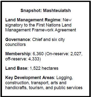 Mashteuiatsh First Nation is a recent signatory to the First Nations
Land Management (FNLM) regime. From their perspective, the FNLM regime is an
important step toward self-government and is viewed as a tool for greater
economic development. They indicated that because their population is
relatively young (50% under 35 years old), there is an imperative to create
economic opportunities for them. They are increasingly looking at entering into
partnerships rather than merely seeking compensation for the use of their lands
by third parties.
Mashteuiatsh First Nation is a recent signatory to the First Nations
Land Management (FNLM) regime. From their perspective, the FNLM regime is an
important step toward self-government and is viewed as a tool for greater
economic development. They indicated that because their population is
relatively young (50% under 35 years old), there is an imperative to create
economic opportunities for them. They are increasingly looking at entering into
partnerships rather than merely seeking compensation for the use of their lands
by third parties. 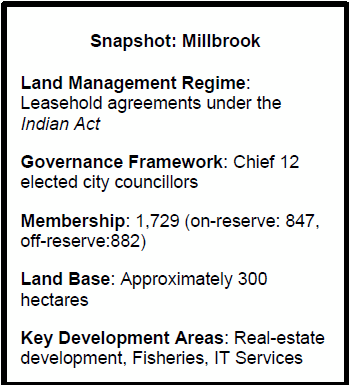 Millbrook First Nation currently operates under the Indian Act
land management regime. In contrast to Mashteuiatsh First Nation, Millbrook has
only a handful of CPs, covering roughly 2% of the reserve land base
(approximately 59 active CPs).
Millbrook First Nation currently operates under the Indian Act
land management regime. In contrast to Mashteuiatsh First Nation, Millbrook has
only a handful of CPs, covering roughly 2% of the reserve land base
(approximately 59 active CPs).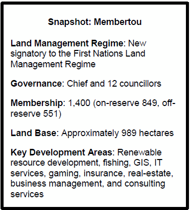 Membertou First Nation is one of several new signatories to the FNLM
regime. To date, Membertou’s economic success has occurred under the Indian
Act land management framework.
Like Millbrook First Nation, Membertou is strategically located in an urban
centre. Today, Membertou is an economic driver in the region, employing 700
people in peak season — close to half of them non-Aboriginal — and grossing
annual revenues of $75 million from band-owned and operated businesses
which are used, in part, to support community programs.
Membertou First Nation is one of several new signatories to the FNLM
regime. To date, Membertou’s economic success has occurred under the Indian
Act land management framework.
Like Millbrook First Nation, Membertou is strategically located in an urban
centre. Today, Membertou is an economic driver in the region, employing 700
people in peak season — close to half of them non-Aboriginal — and grossing
annual revenues of $75 million from band-owned and operated businesses
which are used, in part, to support community programs.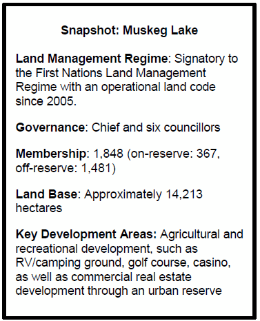 Representatives of the Muskeg Lake Cree Nation (MLCN) indicated that
land is their most important resource. They noted that the First
Nations Land Management Act has given them greater control over their lands
and enhanced opportunities to generate own source revenue (OSR) through
economic development. OSR is used by the MLCN to help support social programs
such as health and education.
Representatives of the Muskeg Lake Cree Nation (MLCN) indicated that
land is their most important resource. They noted that the First
Nations Land Management Act has given them greater control over their lands
and enhanced opportunities to generate own source revenue (OSR) through
economic development. OSR is used by the MLCN to help support social programs
such as health and education. 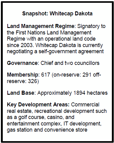 Chief Darcy Bear of the Whitecap Dakota First Nation (WDFN) emphasized
to Committee members that good governance practices, accountability and
transparency have been the cornerstone of the community’s economic success. He
notes that when he was first elected to Council in 1991, the WDFN was nearly bankrupt
with little financial controls or policies in place. In response to these
financial challenges, chief and council established a financial management
plan, consolidated its debt and worked with AANDC officials on a remedial
management plan in order to avoid third-party management.
Chief Darcy Bear of the Whitecap Dakota First Nation (WDFN) emphasized
to Committee members that good governance practices, accountability and
transparency have been the cornerstone of the community’s economic success. He
notes that when he was first elected to Council in 1991, the WDFN was nearly bankrupt
with little financial controls or policies in place. In response to these
financial challenges, chief and council established a financial management
plan, consolidated its debt and worked with AANDC officials on a remedial
management plan in order to avoid third-party management.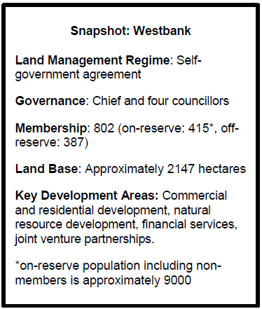 Chief Robert Louie told Committee members that prior to 1990s little
development took place on WFN lands, adding that a stable government, sound legal
structures and a strong foundation of laws has helped to drive development on WFN
lands.
Chief Louie observed that a “proper framework has attracted quality developers
and gives them confidence in the process.”
Chief Robert Louie told Committee members that prior to 1990s little
development took place on WFN lands, adding that a stable government, sound legal
structures and a strong foundation of laws has helped to drive development on WFN
lands.
Chief Louie observed that a “proper framework has attracted quality developers
and gives them confidence in the process.”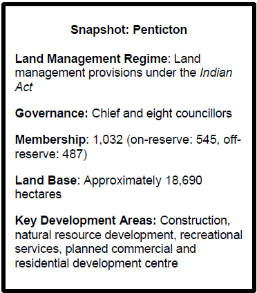 The Penticton Indian Band (PIB) is located in south Okanogan region
in central British Columbia, one hour north of the Canada–United States border.
Only 8,000 acres of reserve lands is useable and much of it is privately held. Three
quarters of PIB land mass is under forest cover, and the remainder is held by
band members under CPs. PIB representatives indicated that this is part of the
challenge the community faces regarding economic development.
The Penticton Indian Band (PIB) is located in south Okanogan region
in central British Columbia, one hour north of the Canada–United States border.
Only 8,000 acres of reserve lands is useable and much of it is privately held. Three
quarters of PIB land mass is under forest cover, and the remainder is held by
band members under CPs. PIB representatives indicated that this is part of the
challenge the community faces regarding economic development.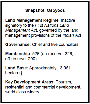 The OIB has flourished and today is widely recognized for its
economic achievements. Chief Clarence Louie attributes this success to strong
and transparent leadership as well as a development strategy rooted in business
principles. While the OIB is a signatory to the First Nations Framework
Agreement on Land Management, efforts to pass their land code were not
successful.
The OIB has flourished and today is widely recognized for its
economic achievements. Chief Clarence Louie attributes this success to strong
and transparent leadership as well as a development strategy rooted in business
principles. While the OIB is a signatory to the First Nations Framework
Agreement on Land Management, efforts to pass their land code were not
successful.